Photo Summit Mount Rinjani 3726 meter asl
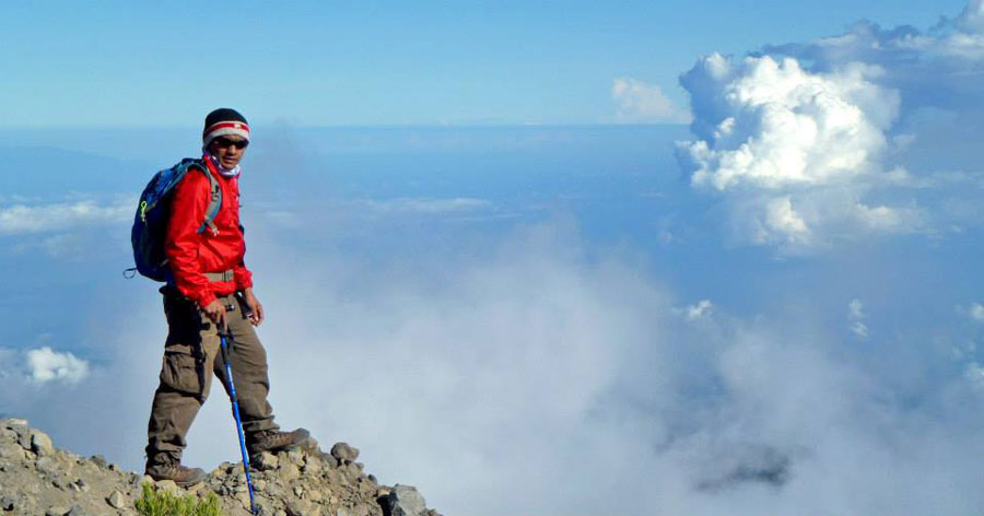
This photo top mount Rinjani altitude 3726 meter asl
Your guide and porter have brought camera as your memories at summit Mount Rinjani here and please visit again photo galleries of all our guests at the facebook page during a hike on Mount Rinjani at www.facebook.com/climbingrinjani/
Mount Rinjani Peak 3726 meter above sea level or 12,224ft
Climbing Mount Rinjani’s summit at 3,726 meters offers a challenging yet breathtaking trek across diverse landscapes, rewarding hikers with panoramic views, a volcanic crater lake, and a stunning sunrise from Indonesia’s second-highest volcano.
Overview of Mount Rinjani
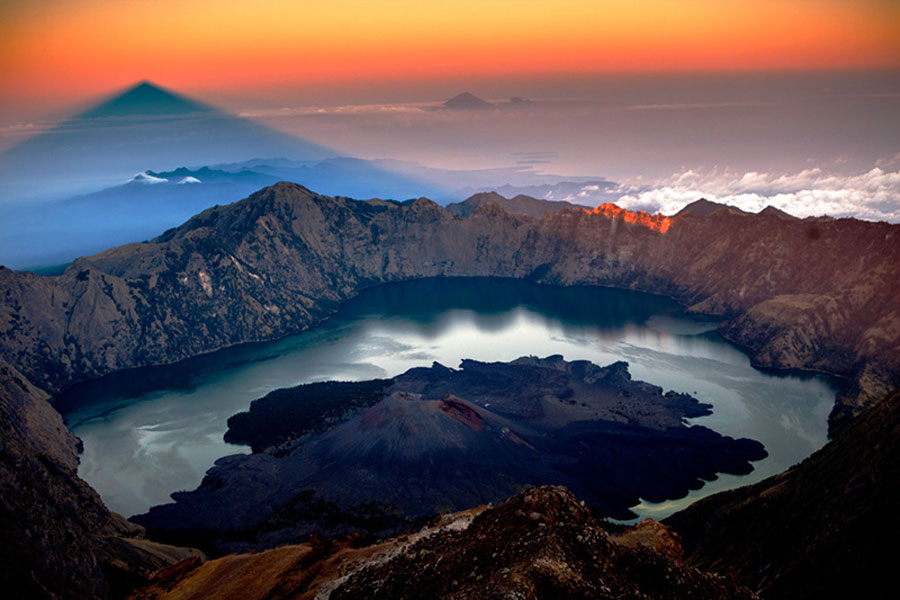
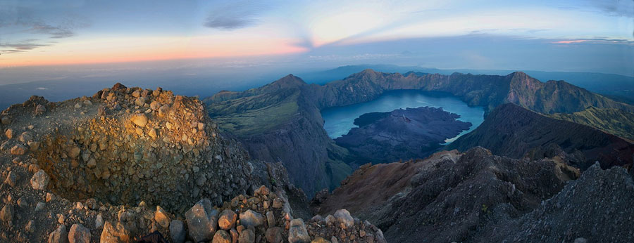
Mount Rinjani, located on Lombok Island in Indonesia, stands at 3,726 meters (12,224 feet) and is an active volcano famed for its dramatic crater lake, Segara Anak. It’s a bucket-list climb for adventurers who want to experience tropical rainforests, volcanic savannas, hot springs, and summit panoramas of Lombok, Bali, and nearby islands.
Trekking Routes and Duration
There are two main routes for climbing Rinjani:
Sembalun Route: The most popular and straightforward. It starts at Sembalun
Village (1,100 m altitude) and offers gentler gradients early on through
savannah and forests before getting steeper near the crater rim. Most
trekkers take 3 days and 2 nights via this route to reach the summit and
descend.
Senaru Route: A traditional, more rainforest-heavy path starting from Senaru
Village. It is scenic but a bit more physically demanding in terms of
terrain variety.
Many trekkers ascend by one route and descend via the other to enjoy
different views.
Typical 3-Day Itinerary
Day 1: Trek from Sembalun village to the crater rim camp
(about 6-7 hours). This trail moves through savannah and grassy plains,
gradually steepening.
Day 2: Pre-dawn summit climb to 3,726 m (lasting roughly 3-4 hours) over
rocky, loose volcanic scree. Enjoy sunrise views from the peak, then descend
to Segara Anak Lake for rest and hot springs. Later, ascend to Senaru crater
rim for overnight camp.
Day 3: Descend back to Senaru village through tropical rainforest,
completing the trek.
Physical Difficulty and Preparation
The summit push is the hardest part — it involves steep, loose volcanic sand and rock that feels like two steps forward, one step back. Temperatures at the summit can drop to near freezing, so layered warm clothing is essential.
General advice includes:
-
Good fitness and endurance are required;
-
Use trekking poles and sturdy footwear with strong grip;
-
Carry a headlamp for the early morning climb;
-
Stay hydrated and pace yourself;
-
Be prepared for significant altitude gain and possible altitude sickness.
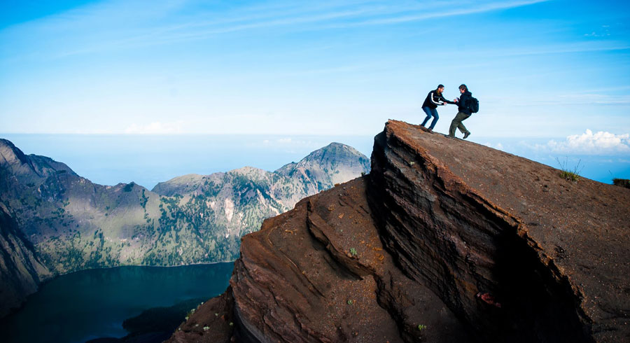
What to Expect at the Summit
The summit experience is truly rewarding. At sunrise, you’ll see golden light spreading across Lombok, Bali, and Sumbawa islands, with the volcanic crater lake and the active cone of Barujari below. The panoramic views are unforgettable and a highlight of the trek.
Support and Tour Packages
Hiring experienced guides and porters is mandatory and highly recommended for safety, logistics, and convenience. We are tour operator offer various packages, including 2-day faster summits and extended multi-day treks. These often include camping gear, meals, permits, and transport from Lombok airport or local villages. Due to limited daily permits (around 240), booking in advance is essential.
Additional Highlights
Soak in natural hot springs by Segara Anak Lake on the
second day;
Experience diverse ecosystems from savannah to tropical rainforests;
Opportunity to participate in eco-trekking programs that focus on
environmental preservation.
Summary
Mount Rinjani summit trek is a physically demanding but
incredibly rewarding adventure suitable for those with a good fitness level
and a spirit for nature and challenge. The stunning sunrise, volcanic
landscapes, crater lake, and cultural significance make it a must-climb
destination in Indonesia.
If you’re planning to climb Mount Rinjani, ensure proper preparation, book
with us as tour operators, and respect local environmental guidelines for a
safe and memorable experience.
This advice is based on detailed trekking guides, local tour offerings, and
expert recommendations from multiple sources providing route descriptions,
itineraries, and trekking tips.
Making it the second-highest volcano in Indonesia and
the highest point on Lombok Island.
Mount Rinjani is an active stratovolcano located in the North Lombok region
of West Nusa Tenggara province, Indonesia. Its summit stands at 3,726 meters
(12,224 feet) above sea level, dominating the northern landscape of Lombok.
This makes it the second tallest volcano in Indonesia, after Kerinci, and
the highest point in the province.
The volcano features a large caldera approximately 6 by 8.5 kilometers in
size, containing the crater lake called Segara Anak, situated at about 2,004
meters elevation with a depth of roughly 200 meters. Inside this caldera
lies an active volcanic cone, Gunung Barujari, which has its own eruptive
history.
Mount Rinjani is part of the Sunda Arc volcanic chain and is known for its
challenging trekking routes that attract adventurers worldwide. The climb to
the summit offers spectacular views over Lombok and neighboring islands like
Bali and Sumbawa. Due to its height and volcanic activity, climbers should
prepare for cold and variable weather conditions near the peak.
Besides its geological prominence, Mount Rinjani holds significant spiritual
value for the indigenous Sasak people and Balinese Hindus, hosting religious
ceremonies especially around the crater lake. The mountain and its
surroundings are protected within Gunung Rinjani National Park, known for
its rich biodiversity and natural beauty.
In summary, the peak of Mount Rinjani is the towering summit at 3,726 meters
(12,224 feet), symbolizing both natural grandeur and cultural importance on
the island of Lombok.
Mount Rinjani with the highest point of 3,726 m above sea
level or 12,224ft, dominates most of the scenery of the northern part of Lombok
Island. To the west of the Rinjani cone there is a caldera with an area of approximately
3,500 m × 4,800 m, extending east and west.
On the eastern side of the caldera there is Mount Baru (or Mount Barujari) which
has a crater measuring 170m × 200 m with an altitude of 2,296 - 2376 masl. This
small mountain last erupted on 25 October 2015 and 3 November 2015, after previously
recorded erupting in May 2009 and in 2004. If the 2004 eruption did not cause
any casualties, the 2009 eruption had indirectly killed 31 people, due to flooding
on Tanggek river due to lava pressure to Segara Anak. Previously, Mount Barujari
had recorded erupting in 1944 (as well as its formation), 1966, and 1994.
Apart from Mount Barujari, there are other craters that have erupted
View Google Maps 360° Summit of Mount Rinjani 3,726 meter above sea level

The peak of Mount Rinjani 3.726 meters

Summit of Mount Rinjani an altitude 3726 meters

Summit of Mount Rinjani an altitude 3726 meters
Summit Of Mount Rinjani 3726 meter
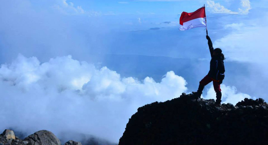
Summit Of Mount Rinjani 3726 meter

To go peak Mount Rinjani 3726 m altitude

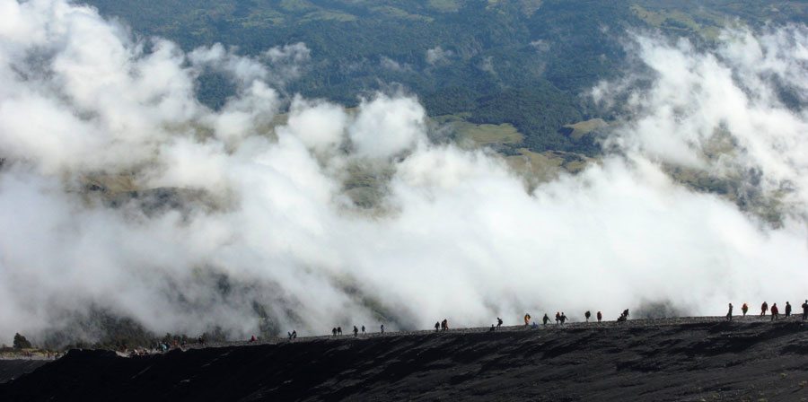
By the time we got down, you trample eroded sand and slipped deep enough, carefully.. and do not run the time down from the summit of Mount Rinjani

By the time we got down, you trample eroded sand and slipped deep enough, carefully.. and do not run the time down from the summit of Mount Rinjani
Rinjani Mountain Summit 3726 meters
Rinjani Mountain Summit 3726 meters

Rinjani Mountain Summit 3726 meters

Rinjani Mountain Summit 3726 meters
Before to go Summit Mt Rinjani
The above Trekking Route starting point from Senaru village to go Summit of Mount Rinjani altitude 3726 meters